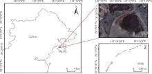
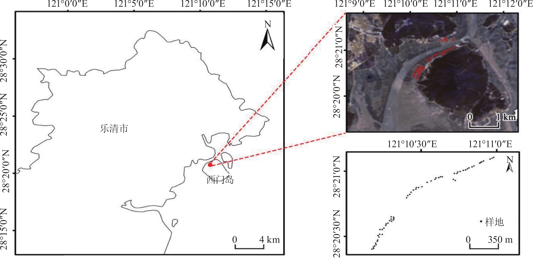
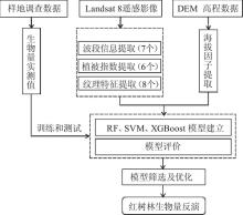
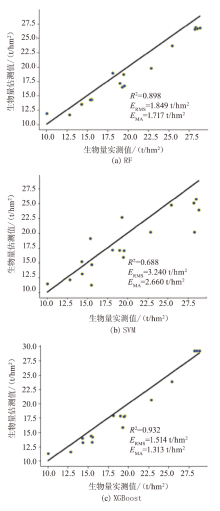
| [1] |
陈秋夏, 杨升, 刘星. 浙江红树林发展现状与思考[J]. 浙江林业, 2022(7):26-27.
|
| [2] |
李皓宇, 彭逸生, 刘嘉健, 等. 粤东沿海红树林物种组成与群落特征[J]. 生态学报, 2016, 36(1):252-260.
|
| [3] |
田义超, 黄远林, 陶进, 等. 基于无人机影像的北部湾典型岛群红树林生态系统净初级生产力估算[J]. 热带地理, 2019, 39(4):583-596.
|
| [4] |
余楚滢, 龚辉, 曹晶晶, 等. 基于无人机影像的无瓣海桑单木提取与地上生物量估算[J]. 热带地理, 2023, 43(1):12-22.
doi: 10.13284/j.cnki.rddl.003609
|
| [5] |
赵越, 徐大伟, 范凯凯, 等. Landsat 8和机器学习估算蒙古高原草地地上生物量[J]. 农业工程学报, 2022, 38(24):138-144.
|
| [6] |
韩爱惠, 智长贵, 王雪军, 等. 利用MODIS数据反演森林生物量的方法研究[J]. 林业资源管理, 2011(4):40-47.
|
| [7] |
周小成, 黄婷婷, 李媛, 等. 结合遥感林龄因子的亚热带森林蓄积量估算方法[J]. 林业科学, 2023, 59(4):88-99.
|
| [8] |
曾伟生, 孙乡楠, 王六如, 等. 基于机载激光雷达数据的森林蓄积量模型研建[J]. 林业科学, 2021, 57(2):31-38.
|
| [9] |
郭正齐, 张晓丽, 王月婷. Sentinel-2A多特征变量反演针叶林地上生物量能力评估[J]. 北京林业大学学报, 2020, 42(11):27-38.
|
| [10] |
郭芮, 伏帅, 侯蒙京, 等. 基于Sentinel-2数据的青海门源县天然草地生物量遥感反演研究[J]. 草业学报, 2023, 32(4):15-29.
doi: 10.11686/cyxb2022147
|
| [11] |
Zhao Fen, Xu Bin, Yang Xiuchun, et al. Remote sensing estimates of grassland aboveground biomass based on MODIS net primary productivity(NPP):A case study in the Xilingol Grassland of Northern China[J]. Remote Sensing, 2014, 6(6):5368-5386.
doi: 10.3390/rs6065368
|
| [12] |
Castillo J A, Apan A A, Maraseni T N, et al. Estimation and mapping of above-ground biomass of mangrove forests and their replacement land uses in the Philippines using Sentinel imagery[J]. ISPRS Journal of Photogrammetry and Remote Sensing, 2017, 134:70-85.
doi: 10.1016/j.isprsjprs.2017.10.016
|
| [13] |
田晓敏, 张晓丽. 森林地上生物量遥感估算方法[J]. 北京林业大学学报, 2021, 43(8):137-148.
|
| [14] |
邢晓语, 杨秀春, 徐斌, 等. 基于随机森林算法的草原地上生物量遥感估算方法研究[J]. 地球信息科学学报, 2021, 23(7):1312-1324.
doi: 10.12082/dqxxkx.2021.200605
|
| [15] |
田义超, 郑丹琳, 张强, 等. 基于国产资源一号 02D 卫星和机器学习算法的钦州湾滨海土壤盐分反演[J]. 中国环境科学, 2024, 44(1):371-385.
|
| [16] |
仇皓雷, 王海燕. 机器学习在土壤性质预测研究中的应用进展[J/OL]. 生态学杂志:1-15(2023-11-20)[2023-12-19]. https://link.cnki.net/urlid/21.1148.Q.20231120.1134.002
|
| [17] |
蔡林菲, 吴达胜, 方陆明, 等. 基于XGBoost的高分二号影像树种识别[J]. 林业资源管理, 2019(5):44-51.
|
| [18] |
林秋莲, 顾肖璇, 陈昕韡, 等. 红树植物秋茄替代互花米草的生态修复评估——以浙江温州为例[J]. 生态学杂志, 2020, 39(6):1761-1768.
|
| [19] |
Gu Jiali, Wu Jiaping. Blue carbon effects of mangrove restoration in subtropics where Spartina alterniflora invaded[J]. Ecological Engineering, 2023, 186:106822.
doi: 10.1016/j.ecoleng.2022.106822
|
| [20] |
Gu Xiaoxuan, Qiao Peiyang, Krauss K W, et al. Changes in mangrove blue carbon under elevated atmospheric CO2[J]. Ecosystem Health and Sustainability, 2023, 9:0033.
doi: 10.34133/ehs.0033
|
| [21] |
陈海生, 金玮佳. 我国最北缘秋茄红树林湿地土壤呼吸变化特征[J]. 广西民族大学学报(自然科学版), 2017, 23(4):100-103.
|
| [22] |
金川, 王金旺, 郑坚, 等. 异速生长法计算秋茄红树林生物量[J]. 生态学报, 2012, 32(11):3414-3422.
|
| [23] |
Weiss M, Jacob F, Duveiller G. Remote sensing for agricultural applications:A meta-review[J]. Remote Sensing of Environment, 2020, 236:111402.
doi: 10.1016/j.rse.2019.111402
|
| [24] |
肖越, 许晓东, 龙江平, 等. 基于国产高分数据的森林蓄积量反演研究[J]. 林业资源管理, 2021(3):101-107.
|
| [25] |
赵翊含, 侯蒙京, 冯琦胜, 等. 基于Landsat 8和随机森林的青海门源天然草地地上生物量遥感估算[J]. 草业学报, 2022, 31(7):1-14.
doi: 10.11686/cyxb2021454
|
| [26] |
Kadiyala A, Kumar A. Applications of python to evaluate the performance of decision tree-based boosting algorithms[J]. Environmental Progress & Sustainable Energy, 2018, 37(2):618-623.
|
| [27] |
谭雨欣, 田义超, 黄卓梅, 等. 北部湾茅尾海无瓣海桑红树林地上生物量反演——基于XGBoost机器学习算法[J]. 生态学报, 2023, 43(11):4674-4688.
|
| [28] |
王猛, 张新长, 王家耀, 等. 结合随机森林面向对象的森林资源分类[J]. 测绘学报, 2020, 49(2):235-244.
doi: 10.11947/j.AGCS.2020.20190272
|
| [29] |
修晓敏, 周淑芳, 陈黔, 等. 基于Google Earth Engine与机器学习的省级尺度零散分布草地生物量估算[J]. 测绘通报, 2019(3):46-52.
doi: 10.13474/j.cnki.11-2246.2019.0076
|
| [30] |
Chen Tianqi, Guestrin C. XGBoost:A scalable tree boosting system[C]// Proceedings of the 22nd ACM SIGKDD International Conference on Knowledge Discovery and Data Mining. San Francisco California USA: ACM, 2016:785-794.
|
| [31] |
李洋, 彭道黎, 袁钰娜. 应用XGBoost算法对森林地上生物量的机载LiDAR反演[J]. 东北林业大学学报, 2023, 51(5):106-112,129.
|
| [32] |
钱忠胜, 俞情媛, 张丁, 等. 结合SVM与XGBoost的链式多路径覆盖测试用例生成[J/OL]. 软件学报:1-26(2023-08-10)[2024-01-08].https://doi.org/10.13328/j.cnki.jos.006905.
|
| [33] |
吴伟志, 赵志霞, 杨升, 等. 浙江省红树林分布和造林成效分析[J]. 热带海洋学报, 2022, 41(6):67-74.
doi: 10.11978/2021158
|
| [34] |
张子慧, 吴世新, 赵子飞, 等. 基于机器学习算法的草地地上生物量估测——以祁连山草地为例[J]. 生态学报, 2022, 42(22):8953-8963.
|
 ), 吕康婷2, 胡天祺4, 王云阁1,5, 徐刚1,6(